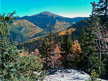
This was a very tough hike. First because instead of following a shore, I had to follow a track up into the hills and dales. And tracks over in Scotland can fade in and out. You think you're following a human track and then you find out that you've been following a sheep track. Signposts come and go as well. Still it all adds to the adventure. . .after, when you're back safe and sound and recounting the tale. While you're on a hill desperately trying to figure out where you are, it's not quite as much fun. I did have an ordnance map and compass and can't stress enough that anyone contemplating a walking holiday have both.
Anyway, I didn't get lost on the first part of the hike, the 3 miles to Loch An Nostarie. I found that Loch fairly easily and admired the views of the small Isles, Rum, Eigg and Muck. I'd be going to Eigg the following day.


And as I circled the Loch and headed up into higher hills on my way to Eireagoraidh (and no I can't tell you how it is pronounced because even though Ian and Angus told me several times I couldn't master it. It sounds something like AnRAYgohray) I realized that An Nostarie was much larger than I had realized when I first saw it.

It was as I left An Nostarie and started toward Loch E that I began to run into difficulties. First the trail disappeared. Yep, just disappeared. I took these next two photos to demonstrate the difficulty in deciding what a trail actually is without the benefit of signposts. This could be a sheep track or it could be a trail. Who knows?

So I consulted the text for the walk and tried to pick out the markers it mentioned. Couldn't see them so, continually consulting between compass and map I climbed higher so I could see. And ran into bog, that deceptive ground that sinks beneath you into smelly mud. And tries to suck your boots off. Ugh. And it was raining too. This is that time when I start to wonder what I am doing this for. I mean, sure, I don't want to be a couch potato but 45 minutes of a strenuous Leslie Sansone DVD starts to look awfully good when you're floundering around on a hill, alone, in the Highlands. And you can see from this photo that I was pretty alone.

But eventually I did see the burn (stream) that was mentioned in the text and, following it, I came to Loch E.

Which looked, that day, quite cold and forbidding. Actually I've heard it looks cold and forbidding every day. And there is no real "shoreline" around it. I scrabbled along shale and brush, got stung by stinging nettles before I decided I'd gone far enough for my taste.
 So I sat down and nursed my sore hand and tried to take in the stillness. After a bit I was aware of the lap, lap, lap of the water. And that was the only sound until I heard rustling and two Scottish Amazons emerged on the trail. Scottish Amazons? I mean two strapping young women wearing bicycle shorts and tank tops and hiking boots who marched quickly past me (with a cheery "hallo and where are you from"), scrabbled a little farther along the banks and then turned around and marched just as quickly past me back and disappeared over the hill. And I was alone again.
Now you'd think that I wouldn't get lost going back, wouldn't you. Ummm--well--I did. First it started to rain--those white spots in the photo are raindrops. First I went up too high in the hills.

Then I saw Loch An Nostarie in the distance so began to head back in that general direction, relying on my compass.

But then I ended up slithering through a large field of tall ferns--that concealed more bog holes--down to the shore of Loch An Nostarie and hopping across shell holes partially filled with brackish water. Ian later told me that this whole area of the West Highlands was sealed off for secret exercises and training during WWII.
Still I finally made it back. That's the beauty of a map and a compass, you WILL find your way back if you use them. Five hours and ten miles after I'd set off, I arrived back at yesterday's Tea Garden to brilliant sunshine (that Highland weather) and had soup and a prawn roll and a cup of the most delicious hot chocolate I'd ever tasted. Then I stopped by Ian's, told him and Angus about the deficits of Angus' trail markers and went back to the B&B to try to scrub the mud off my boots and socks.
Another quiet night of some telly watching and reading.


No comments:
Post a Comment